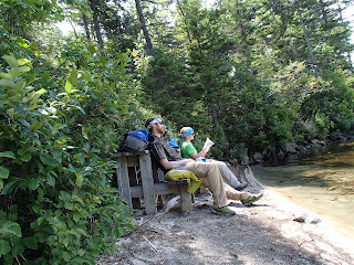
Tuesday, July 31, 2012

"On the Trail?" Says I

"Not Just Yet..." says my body.

We were hoping to be back on the trail this morning. Now we are hoping to be back on the trail either tomorrow morning (unlikely) or Thursday morning. Amid our fun this past weekend, something happened to my foot Saturday afternoon and we are now eagerly awaiting x-ray results that should be in sometime tomorrow morning. I'm not really sure what's going on with it, I only know that the problems started after walking on nice soft sand and putting my foot back into my shoes for the walk back to the car. With the way that it feels and is swollen, there may be fractures inside my foot but I'm really hoping it's only bruised. Only time will tell. On a happy note, Jess's shoulder is no longer in pain and the bump seems to be receeding back from whence it came, so that's really exciting!

I would now like to speak of my new found love for the state of Maine. Saturday morning we left for the coast along Brunswick, only a 2.5 hour drive. We arrived at the parking lot and had to hike 2 miles from there to the beach, as we were in a preserved area. They didn't allow umbrellas, balls, frisbees or any kind of noise making machines at this beach. It was very serene and uncrowded when we arrived. The weather forecast said that there was a 50 percent chance of rain, but we got nothing but sun with a light spotting of clouds. Perfect beach weather. Boldly I stode into the waves, intent on getting a good swim in and also testing the water-proofness of my camera. Both were very satisfying. The bay we were at actually got some good waves (I love diving through them) and I was able to catch a few and body surf a little. Our only complaint was the horse flies, I killed around 36 of them while hanging out on the beach and started my own fly cemetery in the sand beside my towel.


Couldn't find any white blazes...
After spending a good amount of time on the beach, we next headed to an old army fort south of our beach. About 1/4 mile into the walk back my foot felt as if it had started cramping. I figured at this point that it just needed a good walk and to stretch it out. Never stepped on anything but soft sand and the inside of my shoes I've been hiking in. The road back to the car was flat and mostly paved. The fort was as excellent as the beach. There was no park service or anything of the sort to impede total curiosity, and we explored the whole thing. Though it was a little in ruin, most of it was intact and I even searched dark rooms with the flashlight app on my phone. Through the hallways the surf echoed and the windows varied from being completely open, to having one shutter closed or both shutters closed. Being there was surreal, imagining the men who slept and worked inside these stone walls when we had been living completely free inside wooden shelters and our tent for the past month.


We then headed to a new friends house. Shiloh, his trail name, thru-hiked the trail NoBo in 2008 and was very happy to have us there. He had come from Baxter State Park earlier in the day and had summited Katahdin the day previous. After a meal, lots of excellent tips on gear and the mentality of hiking we hit the hay. Sunday came and the four of us headed into Freeport to see the L.L. Bean Super Store. This thing was massive. The only way I can really describe it is to imagine a full sized REI consumed a full size Cabela's and ate a JC Penny's for dessert. The building we went into was monstrous and there were 2 smaller buildings we didn't visit. From L.L. Bean we did some damage to an all you can eat Chinese restaurant and split ways. Dawn headed back north to get fresh blueberries she had ordered, and we went with Shiloh south to Portland. 


See the McDonald's logo? This magnificent house on the left of the photo was the compromise that the people of Freeport and McDonald's came to after denying their request to build a traditional McDonald's building in their town. 
Before getting into Portland we got to see the Portland Headlight Lighthouse. Since the weather was as poor as it was, both the light and the two fog horns were actively communicating with the boats. We didn't pay the fee to enter the museum and climb to the top, but we did learn that a ship had crashed on these rocks long ago and got to see some pictures of it in the gift shop. 


Portland was another awesome city. We went into EMS (East Mountain Sports) so Shiloh could grab some Aquamira and I could try and look for a lighter alternative to my Nalgene. One of the salesmen looks at my headband and says, "Is that a Left Hand Patch?" I had sewn one on to my headband and my pack to represent my trail name (and favorite brewery) and was surprised to learn that he was out here for law school and originally from Boulder. In Old Town Portland Shiloh treated us to some Ice cream treats, and as we headed down the street we saw a massive schooner we decided to go take a look at. As we passed the gates where it was docked, we thought that we wouldn't be able to get any closer as there was a big sign that read "Secure Area" and a guard standing outside. We soon realized it was open to the public, and as we walked up to it realized also that we would be able to go aboard. What luck!


After a little more exploring the cobble stone streets and Maine-accented shops my foot was really fuming, and we decided to head back to Brunswick. About a 10 minute drive from Shiloh's house there's a movie theater and Jess and I borrowed his car to go see the new Batman. As enthralling as the movie was, I checked the emergency exit more than a few times. My heart goes out to those people and their families in Aurora.

Monday morning we took another walk (I had borrowed Shiloh's bike to stay off my foot) to another beautiful bay in Maine. I got pretty sunburned on the beach Saturday and only that stopped me from plunging into the ocean once again. Back at the house we enjoyed a full pan of nacho's, said a fond farewell and made the drive back to Rangeley. We also found out that Shiloh and Dawn may be able to hike a section with us after labor day and Shiloh will be in Georgia about the time we (still) plan to finish our own hike. The prospect of being able to meet them again on our journey is truly exciting!


Jess and I had always wanted to see the coast of Maine, and this weekend we got to do just that plus a whole lot more. It was an amazing experience we didn't think we would get on our thru-hike. Another reason to be grateful! Now, we're sitting at the closing Rangeley library and about to be kicked out. Just can't type fast enough sometimes to get it all out. Wish me luck with my foot, hopefully our next post will be from on the trail or New Hampshire! 

Thursday, July 26, 2012

Words Fall Short

There are times in life when words just can't truly define what I wish to say. We are still in Rangeley, being well cared for by the family who took us in last Friday. But we haven't been idle. In addition to making sure that we are comfortable, and Jess's shoulder is being taken care of and getting better, they have been slack packing us through some of the final sections of Maine. In the past three days we've completed another 36.6 miles, including Bemis mountian that all of the NoBo's have been complaining about.

Words have fallen, now, far short of the gratitude I would like to express. Our relationship has also grown from hiker-trail angel to that of lifelong friends, and it will be such a pleasure to be able to keep in contact after our hike is complete. I really hope we can persuade them to come and stay with us in Colorado.

In the wake of the recent movie theater tragedy, Jess and I have found ourselves full of our first dose of culture shock. On the trail, every person we've met cares about the other hikers and we have become a part of a community where complete strangers help one another. Hikers are not alone out here. NoBo's and SoBo's share information along the trail about what's coming up, parts to look out for and how the water sources are. Day hikers have asked us how we are and if we could use any fresh food. We all make sure that everyone is taken care of when it comes to first aid; sharing vitamin I (ibuprofen), band-aids, antibiotic ointment, moleskin and anything else a hiker may need. It comes as a great surprise that there are people out there who wish others harm, and for no reason at all. If only life could be as hiking the Appalachian Trail is. Out here we realize we're all on common ground, have the same basic needs and abilities to offer much needed help to one another.

Many people we've helped (or vice versa) we chanced meeting. They were only there for a matter of minutes, hours. We will probably never see any of them again but we feel them in the next successful step that we take. A step that we may not have been able to take without that help. Much of the success of our hike now Jess and I will owe to our new friends. We couldn't have afforded to stay in Rangeley and Jess couldn't have carried her pack any further. This easily could have been the end of our thru hike but instead is another step in the path. I will be forever grateful.

Day 1 of slackpacking, we found this awesome beach on the shore of Sabbath Day Pond, just south of Sabbath Day Pond Lean-to.
As I said, though, Jess and I have not been idle. Our slack packs have been great fun as each time we're dropped off at the southern point, and then we hike back north. We passed a few fellow southbounders who looked at us oddly when we told them we were SoBos too, and then even more oddly as we crossed paths again the next day. We've also seen all the white blazes NoBo's get. There's tons of them! Often as we're hiking south we'll have to turn around to look for them to confirm we're still on the trail.

Jess coming down a section that's just before Moody Mountain

There could be quite the waterfall here when it rains!
It was a great three days, we hit four mountains (none over 4000 feet though) and are within 30 miles of finishing Maine and entering New Hampshire! Mahoosuc Notch still stands between us though, known to all as "the most difficult or fun mile of the AT". We have one more day of slack packing left before we're out of reasonable driving range, and we've taken up an offer to visit the coast of Maine this weekend. In one of the lean-tos we stayed in there was a piece of graffiti that read, "It's not about the miles, it's about the smiles!" Jess and I are building up the latter and truly enjoying our time here. We've always wanted to see the coast and were a little bummed that we haven't even been able to catch a glimpse from the top of a mountain. Oh how those tables turn.

Jess's shoulder is getting better and we'll be on our way soon after our visit to the ocean. Also, I cut the beard off last night and got my hair cut today. It's like a vacation from our vacation!


Saturday, July 21, 2012

Trail & Mail Update #2

Miles Hiked: I don't have the guide on me... somewhere over 200
Miles Ahead: We're under 2,000! Woo!
Mail Drops: To send us something, it has to come USPS (the post office won't hold anything from FedEx, UPS, etc). Address it like this:
Andy Jensen/Jess Quig
C/O General Delivery
[Town, State   Zip]
Please hold for AT hiker
ETA [Date]
Next up:
  • Gorham, NH 03581 (ETA 7/31)
  •  Hanover, NH 03755 (ETA 8/10)
We're coming up on some of the most notoriously difficult parts of the AT--Mahoosuc Notch and the Whites of New Hampshire. Hopefully we'll pick up pace after those!

From Stratton to Rangeley

We left Stratton after our 4th zero day. When we arrived in Stratton Jess was having some knee issues (more muscle related than anything) and we decided to take another day off to allow her knee to heal up. Our spirits were high as Sue dropped us off at the trailhead and we prepared for the five mile climb to the top of Crocker Mountain.

Remember that shirt I was super stoked on? The one I thought would be a lot tougher and last a lot longer? Yeah, big holes. Didn't make it 5 miles.

The top of Crocker Mountain was unfortunately just as dissappointing. It was the first mountain we had climbed with an altitude over 4000 feet that didn't have a view. Wasn't above treeline. We decided to push down to our next stream fording and camp by the bank. It started to rain that day. We climbed up and down super slippery rocks and slogged through some more mud. Kind of a bummer.

That next day we climbed again in the wet and the cold, trying to get past that next lean-to. The hiking that morning was pretty incredible though, it wasn't raining and we were dipping in and out of the clouds along a ridge, so most of the walk was through the misty forest. Definitely a neat experience.


Along the trail, we then ran into a mouse! Poor little guy was curled up into a ball sitting on a rock on the trail shivering. He was so helpless, doing anything he could do get some sunshine or warmth, he didn't even move when we walked up to him. As he was sitting there I realized I was confroted by my first hiker philosophy/karma crossroads. Should I just leave the little guy to fend for himself and live by the hiker code of 'don't feed the animals'? Or should I give him what help I can and take this as an opportunity to earn some good mouse-karma? I chose the latter and gave him two pieces of dehydrated strawberry and a few almonds, hoping that the sugars in the strawberry would help to warm him and the almonds would keep him going until he could get more food. I sure hope he's alright.

 Shortly after leaving Biscuit (we named the little fella), we hit our 200 mile mark at the plaque that commemorated the completion of the last section of the Appalachian Trail!
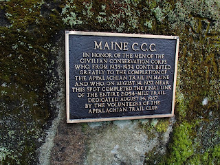
 
2,054 miles long!? That would've been nice. It's 2,186 now!
Things really started to pick up then, as we arrived at the next lean-to we completed a quest that we were set upon many miles ago: The Quest To Find Rayo! This particular lean-to (wish I could remember the name) was off the trail on a blue blazed route. We got there and met two French-Canadian section hikers and two other SoBo's called Poncho and Pepper. It's always nice on the trail to have a) company and b) a roof over your head in the rain, so we decided to stop short and stay there, rather than press on a have to set up our tent in the wetness. It turned out to be perfect, because in comes a northbounder stopping for lunch.

Here's the backstory. Miles ago we got an email from Patti, asking us to tell her son Rayo that she says hi when we pass him. Naturally we thought this was awesome, and I'll be darned if I didn't ask more than a few NoBo's we crossed paths with if they were Rayo. But when we started talking to this particular NoBo in the hut, I chose just to ask him his name. When he told us it was Rayo, we both just stared at him with our mouths open before telling him that we'd been looking for him and his mom says to say hi! To this he replied, "Who are you guys?!" It was all very funny.

From Left: Left Hand, Rayo, and Aves ;)
So, with our spirits back up (one of the French-Canadians had green thread and allowed me to repair my shirt) and the sun out once again we strolled on. We put in a good day complete with a stream crossing and over Jr. Saddleback Mountain, and stopped at a new campsite at the base of our next summit. Poncho and Pepper had planned on stopping there too, and we found them on one of two decks built for tents. Quite the luxury item!


The next day we only planned to hike seven miles, so we spent the morning in our tent relaxing and watching tv shows on our iPods. It was a good little break but it sure did make it that much harder to get going. Especially since this was about the time that Jess developed a swollen bump underneath the skin on her right shoulder that was making it difficult to carry her pack (more about this in a little bit). We made it though, up and over two more peaks with incredible views and down the other side to Piazza Rock Lean-to. The wind had kicked up at the tops of the mountians, so we didn't get to spend as much time as we would have liked up there, but the hike was really great.

Jess descending Saddleback Mountain
Our plan was originally to try and get through Rangeley without paying for a night. It's more of a resort town so the hotel rooms are pretty expensive. From our campsite at Piazza Rock Lean-to to the road was under two miles, and we did that hike fast early in the morning. When we got to the road, Jess couldn't have any pressure on that swollen part of her shoulder, so I grabbed her pack as we headed toward Rangeley (9 miles away) trying to hitch a ride. Hitching didn't take long but we did have to walk past a couple long sections of road with guard rails so that somebody would have a spot to pull over. Joe, a local business owner scooped us up in his truck and drove us to the medical center.

We weren't there for long even though they didn't really know what was going on under Jess's skin. The guess is that it's an infected bug bite, so they put her on antibiotics and told her that she needs to make sure she doesn't start running a fever, which would be a sign that the meds aren't working and we need to get her back to the doctor. Since yesterday, so far so good.

Then, Rangeley turned magical. The company Outdoor Research is warranteeing our gaiters, my head net and my other shirt for us, all of which got holes or had broken buckles. The store where I bought my new shirt allowed me to exchange it for another of a different material. We had tons of awesome stuff waiting for us at the post-office (a massive thanks to both our Moms and to my Grandma for everything that's going to keep us going on the trail)! And in the hours that we were at the post office sorting through our stuff and trying to figure out our next move around Jess's shoulder we met our first trail angel


To be fair, we did send two of these boxes to ourselves from earlier on the trail. Still an impressive haul! OH and my newest shirt!
She and her parents took us in, allowed us to shower and do laundry and are keeping us today so we can zero while waiting for the antibiotics to kick in (and hopefully while the pain subsides). Not to mention that she is a retired nurse and has been helping Jess by putting on charcoal compresses to draw out any bacteria and administering hot and cold treatments for the swelling. We find ourselves truly blessed to meet such wonderful, caring, kindhearted people in our time of true need.  

We're both still doing great, but Jess is currently in a good bit of pain. I'm not sure what our pace will be like from here, but we have trailnames and 200 miles under our belts!


Friday, July 20, 2012

Trail Names

We have our trail names! Mine is Left Hand (after Longmont's Left Hand Brewery, and not to mention I'm left handed) and Jess's is Aves (pronounced Avies, after the biological classification of the bird family). Hers is also funny because her prescription sun glasses are aviators, which is the connection everyone makes upon hearing it for the first time.

We've made it to Rangeley, ME on schedule and hope to get to the library at some point today to put up a quality post.  Aaaand, the new Batman movie is out today so we're gonna try and squeeze that in too. Busy day!

Oh and another highlight-- We've also completed more than 200 miles of the trail! Hooray us!

Sunday, July 15, 2012

Ponderings

Before leaving for the trail, I had a lot of conversations revolving around our hike-but the one that's lingered in my mind the most has, perhaps ironically, been about all the thinking time I'd have out here. What the heck would I think about? (I wondered with my coworker) So much of my world has revolved around teaching for the past few years. I worked intense out of school hours, all of my local friends worked in the district, and Andy spent half the day in the same building I did. So we talked about school a LOT and (inevitably... sadly) school would wind up I'm my dreams. If that's not bad enough, sometimes I even dreamed about being back as a high school student myself. Which leads me to the question I pondered with my coworker: What would I think about when the main objective of each day was just to hike? Well... it's kind of weird, to be honest. For the first week or so, my thoughts were kind of like radio stations. Sometimes I'd even get the kssshh noise as I switched from one thought wave to the next. The same Joshua Radin song played in my head for at least five or six days... only to reemerge again after a few days of peace (at which point I pulled out my iPod). I searched my memory for the most delicious flavor of ice cream I could fathom (Ben & Jerry's Cinnamon Bun: "Caramel Ice Cream with Cinnamon Bun Dough & a Cinnamon Streusel Swirl") and then fixated on it so intensely that I passed up ice cream altogether at the next town because they didn't have the right kind. Andy and I have pondered questions like 'why do beavers build dams?', 'what do mosquitoes eat when they're not eating us?', and 'what do frogs do in winter?' One evening we were still hiking when darkness was closing in and all of the AT's horror stories started sloshing around in my head, haunting the growing shadows. But there's also a pretty good bit of time when I'm really not thinking about much of anything but whether going to the right or left of a tree looks easier or if stepping on that rock or that root is less sketchy. But my favorite description of the funny tracks of hiker thoughts is here: http://appalachiantrail2010.blogspot.com/2010/09/water-spigot.html?m=0
And as a notable aside, I very nearly finished a half gallon of ice cream all by myself (cookie dough, I'm a bit sorry to say). Near the end I was just picking out the chunks of dough, but it shouldn't be too long before I can polish it all off! Yeahhh hiking metabolism! :)

Saturday, July 14, 2012

No Laptop...But WiFi!

It seems we have begun to hit the crazy north-bounder rumors that included a loaner laptop at the Stratton Motel. Along with these false rumors we also heard that the 'Wolf Burger' at the Wolf Inn down the street came with an egg on it. That one wasn't so bad, the burger still had cheese, bacon, an entire sausage party (a burger first for me), lettuce, onion, mustard, mayo, and relish. All the calories a thru-hiker needs. But still, no lap top so we're going to have to try and find another way to get our pictures up here. Bummer, too, because we are building quite the collection.

Our last post came from the top of Avery Peak which was a monster climb. From there we headed down and up again to West Peak, about another 500 feet of elevation gain. West Peak was actually about 100 feet higher than Avery and the view opened up to a full 360 degrees. We get amazing views from the peaks in Colorado and the views from these peaks in Maine 10,000 feet lower are equally amazing. Even with the haze brought by the heat of the day our line of sight was still barely impaired. There was Canada to the north and west, we could see Sugarloaf mountain to the south and a whole lot more I can't even name.

Alas, what goes up must come down. We heard from an uber-hiker trail named Lake (he's done the PCT, CDT, an we met him on his third AT hike, only this time he's going from Key West, FL all the way to Newfoundland) that the AT is the hardest of the long trails for this reason: hikers go up one mountain, hit a few peaks along a ridge and then drop back to the bottom to hike a few miles before heading up the next. It kind of makes me feel like a bouncy ball.

Early on in our hike, more NoBos (just a wealth of wisdom) told us we'd come to love the ups more than the downs. I've figured out a few reasons why:
1) Up causes temporary muscle burn, down causes lasting joint pain.
2) Up generates a massive amount of endorphins, or a "runners high" resulting in smiles, laughter and a desire for more.
3) Up there's a breeze, a summit and views ahead, down there's humidity and bugs. Lots of bugs.
4) Down isn't really any faster when climbing down generally requires either butt sliding or chucking hiking poles downhill so that hands are free to grab onto tree trunks for better leverage.

Last night we made it to the Horns Pond Lean-tos which actually was an established campsite with a caretaker. We met some locals and a little girl gave us some delicious sugar-snap peas. Delicious. Fresh produce has become a delicacy I'm happy to say. There were two lean-tos that were clean and well kept, and the privy didn't even smell too bad. This morning we had to get into Stratton before the post office closed and we made the 6 mile gap in just over two and a half hours. For almost the whole hike I was forcing myself to breathe through my nose. It was a stretch of fresh, young pine forest. I couldn't get enough and the funny thing was it reminded me of the smell on the E.T. ride at Universal Studios in Orlando. Which is exactly what they were going for. I tip my hat.

Sue and her dog Knucklehead who thru hiked together in 2004 and own the motel picked us up at 10:55. The post office closed at 11:00, but we made it. Got into town, hit the grocers and the outfitter and saw our second bull moose eating in a stream next to the road! Thanks to Amy and Jess's grandparents for the package with the cookies! Right now they're actually hidden upstairs. Just too good to share at the moment.

For the moment we're dry, full and fully resupplied which is a great feeling. I also got another new shirt, this one is tougher and will hopefully last longer than the two weeks the last one made it. Seriously, I sneezed and that shirt got a hole in it. I am looking forward to showing off my new found spiffy-ness in the upcoming photos. But it's bedtime, more smiles and more miles on the 'morrow!

Friday, July 13, 2012

Quick-Post

Jess and I are sitting on the top of Avery Peak right now, just over 4000 feet after a 1900 foot climb. Sure feels great and the views are incredible. We just met a local hiking north with his son who pointed out Canada. We will be in Stratton tomorrow where we've heard we can borrow a laptop, so a longer post with pictures should follow. Since Monson our weather has been awesome and shows no sign of changing. The trail has been nothing but fun and we can't wait to share the details!


Thursday, July 5, 2012

Trail & Mail Update #1

Miles Hiked: 114.5
Miles Ahead: Let's not think about that just yet
Mail Drops: To send us something, it has to come USPS (the post office won't hold anything from FedEx, UPS, etc). Address it like this:
Andy Jensen/Jess Quig
C/O General Delivery
[Town, State  Zip]
Please hold for AT hiker
ETA [Date]
Next up: (the ETAs have a major emphasis on the "E"... but we're "E"ing on the early side, so we shouldn't arrive ahead of anything and the post office will hold them as long as a month)
  • Rangeley, ME 04970 (ETA 7/12)
  • Gorham, NH 03581 (ETA TBD) ... I don't have this section of our guide right now (sent  ahead), so I'll try to remember to update this when I can!

Wednesday, July 4, 2012

The First Days

Mt. Katahdin as seen from Abol Campground. Yeah...I took this picture!
Before I start, my Grandma celebrated her birthday last Thursday the 28th, so I just want to say: Happy Birthday Grandma! Sure hope we get to see you when we get to New York!

It was truly a great start to our hike, all troubles aside. Jess and I are still thrilled to be out here on this amazing adventure, and we've got the 100 mile wilderness under out belts! There's a ton to say (and a ton more I've forgotten, I'm sure) about the start of our hike, so I'm going to attempt to break it all down. I'm sure there will be some overlap too so forgive me, but it's all stuff we'll want to remember when we read this blog 20 years from now :)

Day 1: Getting to the Trail & Summiting Katahdin


Ole Man from the AT Lodge gave us the ride to the trail head at 6:30 in the morning. It was a little under an hour drive, mostly uneventful except for a fawn that got so startled when we came around a corner in the car that it actually skid on the dirt road before bolting into the forest. It gave all three of us a good laugh. When we arrived at the ranger station we unloaded our essentials and borrowed a couple of day packs they keep for hikers just like us. Nice to only carry about 10 pounds up the mountain rather than 50. Before we left the station the ranger inside told us, "If you hear thunder, just turn around..."

Our hike up was hot, super humid and very sunny. We had heard about hikers that had gotten some hospital-quality sun burns on the top so we were prepared. We weren't prepared for the climbing. There is a good section above treeline where the route requires hand over hand climbing, and in several spots iron rods have been planted in the rock to use as hand/foot holds. After all the climbing there's another 2 miles of decent enough incline and spots where the terrain flattens out. Those who know the mountain have a name for it, but I don't recall what it is.

When Jess and I got within a mile, and could see the famous sign at the top of the mountain, the thunder rang out. It was a good distance away, but we were told to turn back if we heard it. And we would have. But we were too close and didn't want to hike all the way back to the top. The decision was made to hustle up, take the pictures we needed to prove we were there, and hustle down. Also, like Jess said, we couldn't consider the 5 miles (and 2400 feet of elevation) we had just done as part of the AT. This was all approach trail.

Getting to the sign was so rewarding! We did the last quarter mile almost in the fog but it cleared a little as we got to the top, just enough to see how high we had climbed. Funny thing was we were still below Denver's elevation. But as the storms we were warned about were rapidly approaching, we had to snap some quick pics and hustle down.


The famous sign and the official start of our hike!

The climb down was heart pounding. The thunder was getting closer and closer and closer. Finally, right before we hit tree line (thankfully we were underneath huge boulders so we were no longer the tallest things around) a bolt of lightning hit behind us, so close we heard whatever it hit sizzling with the electricity. Too close. We've learned our lessons, though, and will be seeking tree line on every moody mountain we come to now. 

Then the rain started to fall, and pour. It was a very wet descent. Thankfully we had a lean-to that night, so we set the tent up inside of it as a bug screen, ate a good meal and quickly fell asleep.

Day 2 & 3: To Abol Campground and Our First Zero


The next day we were SORE. Katahdin kicked our butts. We felt like if we kept moving, we'd loosen up a bit. Not. We ended up hiking in the rain just about all day, but the trail at least was flat. It was a long day gone when we made it to the little store in front of Abol Campground. Ole Man told us we had to try the Whoopie Pies there, so we stopped in to grab them and a campsite. $10 got us a campsite, but upon discovering the menu on the wall, we quickly spent more for some hamburgers.

We got to our site and set our tent up in the rain, once again crawling in to fall asleep almost instantly. Gotta love the Big Agnes Q-Core mattress. The next day passed by fast, we knew we were leaving the next day and the weather seemed to finally be cooperating. We were still super stiff, but ate some good food at the store and kept walking around. We were even able to watch a bull moose eating in the lake as he passed through. Must've been 7 ft tall.

Now, though, for the scary part. We had discovered an electrical outlet in the bathrooms and gone back to charge our phones and cameras. This was about 9 o'clock. Near 10-ish I walked out of the men's bathroom over to the women's room too see if Jess had gone to bed. Thankfully, she had. I turned around to go back and grab my stuff when I heard a snort, and there about six feet in front of me was a black bear. Not sure how or why I didn't panic, but I looked at him and he at me, then I calmly walked back into the men's room. Adrenaline pumping, I told the other guy in the bathroom (a fellow SoBo named Yash who we met on Katahdin) there was a bear outside. We watched as the bear tore into the trash can guard, grabbed a regular size metal can and dragged it into the forest. Later that night, Yash who was camped next to us heard him going after our food bags. Our we tied "PCT style" in the tree (future thru-hikers-- learn this tactic!) and his was in an "Ursack" which is a type of bear proof bag. We found some teeth and claw marks on his bag the next morning, but it was otherwise undamaged. All of our food was fine.


Days 4-12: The 100 Mile Wilderness


The next few days were spent in pouring rain. I set the tent up and took it down in the rain. We got ready to hike and left our warm sleeping bags in the rain. Two hikers actually gave up, dumped there food in a pile at there campsite and turned around. 


The trail to White House Landing felt rough, it was flooded and muddy, but we didn't know anything yet. We hadn't really even gone up a mountain since Katahdin, and there were a few coming up. Thankfully, we got through the entirety of it with no major injuries and were feeling good now. Although, on day 10 my Katadyn Vario Water Filter quit working, even though I took it all apart and put it all back together in what seemed to be perfect condition. Then on day 11 my SteriPen stopped working too. It tells me that the bulb (which is supposed to last a very long time) needed to be replaced, and I had only treated maybe 50 liters with it. We were lucky enough to be able to rely on other hikers to get drinkable water. I was actually able to call my mom (thanks mom!!!!) from the top of Chairback Mountain to buy me replacements from REI and overnight them to us here in Monson, which I will be picking up tomorrow when the post office reopens. I'll be sending the broken ones back to her so that she can return them and get her money back. I really just love REI at moments like this. 


But to sum up the 100 Mile Wilderness, I'd have to say, kind of false advertisement. There's actually two hiker hostels inside the wilderness that will feed you, provide resupply and a place to stay for the night. There's a stream to ford near the southern end of the wilderness that is .2 miles away from a very busy parking lot where a hiker in trouble could find a ride to town if needed. But it's relatively easy as long as you're prepared. We were actually over prepared and sent a bunch of stuff to Caratunk from White House Landing.
Yeah..whatever
Alas, I could write a ton more but it's getting late here. Our new bedtime is around 7 now and we wake up at 5 in the morning (even though the sun actually rises at 4:30 here). I have to say that we've met so many wonderful people, and everyone is so helpful and supportive. Yash is a good friend, and I'm sure will be down the trail. We also met a triple-crowner who is on the AT for his third time, although this time he's doing the International AT and started in Key West, Florida. There are too many others to list. But before I go I have to give a shout out to Rollie and Priscilla who rode with us from Bangor to Millinocket:

To Trail Blazer and Pokie Okie:
                Since White House Landing we had heard of a hiker that had become exhausted on Katahdin and had to be rescued on a stretcher from near tree line. We were so relieved to see your comment on our blog and finally know for certain that this wasn't either of you. It was tough to find our food drop and not see a bucket there for the two of you. 
                I'm sorry to here that you had given up after Katahdin, but that mountain was hard. Extremely hard, even for us and the 100 mile wilderness didn't get any easier. But don't hang up the boots yet! Head to Colorado, find the Wild Basin Trail Head and hike in to one of the campsites there. You'll need a permit from Rocky Mountain National Park, but it's worth it. The trails are excellent and maintained, and you'll still get beautiful views and the remote experience, especially if you can make it to the sites at Thunder Lakes, which if I remember is an 11 mile hike one way. Also while in Colorado get to Estes Park and hike in the national park, then drive over trail ridge road through the towns of Grand Lake, Granby and Winter Park. 
               We were sorry not to see you in the wilderness, but are glad you are both safe. Please email us if you would like any more suggestions of hikes or with any questions or comments as we continue on this journey. 
                                             Happy Trails! --Andy and Jess

Rain, Pain, & Serendipity

And so begins the madness! We're finally out of the Hundred Mile Wilderness and staying at Lakeshore Lodging & Pub in Monson. Andy wanted to stay here because when he read the part of our AT Guide said our stay would include free kayaking and a water trampoline he was like a kid at Christmas. So in order to finagle our zero to fall on the fourth we really pushed it these last few days... but so much has happened over the past week and a half that I need to back up and attempt to go in order, starting back at that beast called Katahdin.

Now the tricky thing about starting the AT at the northern end is that technically our hike wouldn't start until we'd summited and begun hiking back down. And the day our hike started there was a 90% chance of thunderstorms, so the rangers were warning most hikers off of going to the summit... but we'd already been delayed a day (from the late plane that made us miss our bus) and we were feeling good. I can't say we weren't warned of the weather or the challenge--but I think to say that Katahdin kicked our butts doesn't even begin to cover it. We went up the 'easier' Hunt Trail, and a pretty good portion of it was bouldering (which we weren't expecting) and very rough trail. The funny thing is that when we tell people we're from Colorado, they're immediately impressed--like this should be easy for us. And we kind of thought so, too. Before. But even at high elevation, most trails we've done in Colorado are really smooth and have a well-established feel, and trails out here are just ridden with roots and rocks. There were two or three places hiking Katahdin that even had metal bars drilled into boulders so you could hoist yourself up or down a rock face. That would've been plenty to take on, but there was also a storm building up as we got above tree line. So we raced to the summit (more ridiculous trail), snapped a couple pictures, and raced back down as fast as we could manage. I was so terrified of the boiling storm and booming thunder that my whole body was shaking--and just as we were nearing tree line a bolt of lightning burst at the ground probably 100 yards away, so close Andy says he could hear it sizzle. I've honestly never feared for my life the way I did as we raced for those trees. My stomach feels queasy just thinking of it... of course, that may be partly the french toast, bacon, eggs, potatoes, sausage, orange juice, and coffee I had for breakfast.

Which brings me to my Coulda Shoulda List. I can't speak for the rest of the trail, but for this section (Katahdin & the 100 Mile Wilderness) here's what I'd do differently. And trust me when I say I've had a good bit of time to ponder this list :)

  1. Wait until a great (or at least decent) weather day to hike up Katahdin. It's a huge effort to get up there, so you may as well get a view at the top and, you know... survive. Also the rangers will do their best to help you change camping arrangements (you have to book camping to stay in the park, but the rangers don't want to have to rescue you!)
  2. Consider (non-waterproof) trail runners in place of boots. Trail runners are like beefed up sneakers. I have waterproof Gore-Tex boots, and I love everything about them except for how effectively they hold water. There are so many streams to ford out here (plus so many puddles) that we just started plowing right into the water with our shoes on... and then I'd slosh along in my boots until the next ford. Trail runners get faster, but the water also has a chance to leak out.
  3. Bring extra toilet paper... and then bring more extra toilet paper. We almost ran out, and it was at the point that I'd stopped blowing my nose for fear of getting down to leaves. I don't know about you, but I'm really not okay with leaves.
  4. Bring more ibuprofenI'm not much for taking pain-killers, but with my body still breaking into the hike I can't make it more than a few hours in the morning without some ol' vitamin I to subdue the aches.
  5. Pack less weight... and then pack even less weight. I think this is going to be a continuous process, but some of the things we sent out at White House Landing (close to halfway through the wilderness) included my fleece, Andy's vest, an extra Camelbak (there are vast quantities of water in Maine--no need to carry extra), and antiperspirant. We'll probably also send away our down jackets since it's been a lot warmer than we'd expected--we're so used to Rocky Mountain weather, we were thinking it'd be a lot cooler in the evening. In retrospect, there are even more things I would've shipped to Monson just to start with less weight...  like my iPod and chargers (not many chances to charge before here anyway)

Alright, well it's the Fourth of July and Rebekah (one of the owners here) is going to take us to Greenville to resupply and watch a parade! I guess I haven't really addressed the serendipity part of my title, but let's just say that despite everything that has gone wrong (delayed start, lightning, failing muscles, failing gear (everything from Outdoor Research has broken!), a bug bite over my right eye that bled and then blew up like a balloon, mosquitoes, black flies, obscene quantities of rain, temporarily getting lost, falling, rashes, a scary hungry bear encounter... that's Andy's story more than mine), I feel really, truly happy to be out here right now doing just what we're doing. Happy Fourth!