Sunday, April 29, 2012

The Challenge

Starting in June, we will be walking from Mt. Katahdin in Maine’s Baxter State Park to Springer Mountain in Georgia. If you factor in the extra walking we’ll be doing (such as getting into towns), this distance will be comparable to traversing the Atlantic from Canada to France. The odds of success are low. Of the 1,700 northbound hikers who registered with the Appalachian Trail Conservancy in 2011, 849 made it to the halfway point (an ATC station in Harper’s Ferry, Virginia) and 432 made it to Katahdin. That makes ~25% completion rate—pretty close to that of an average year.

I’m sure there are a myriad of reasons people stop doing things in their lives, and when you throw in the physical and emotional challenges of hiking and camping in the woods, then stretch that over many months (while not making any money)… it’s not too hard to imagine a person getting to mile 500, thinking about eating the same ramen noodles for dinner that’s he’s eaten for weeks, then stubbing his toe for the eighth time that day and deciding ‘that’s IT.’ I’ve followed quite a few AT blogs, and the posts generally stop after enough seemingly small things add up.

Now, I’m not a terribly competitive person (one of many reasons why I’m unlikely to be picked first for kickball) but if someone even suggests that I can’t do something it triggers this strange, bubbly heat somewhere between my heart and my stomach. Some may suggest a resemblance to acid reflux, but my suspicion is that this is where my stubbornness has decided to take root. When this heat persists unsquelched by my brain, great things can happen—and that’s how I feel for this hike. In this case, though, there hasn’t really been anyone suggesting I can’t do this. Trying to talk me out of it, yes. Telling me outright that I may not be capable, no… except for those statistics. So if you discount the bears and the rattlesnakes (let’s not talk about those right now), it’s really the trail and my own limits (real or imagined) that I’ll be up against out there—a perfect plotline for adventure. And so to the trail (and myself) I say: Challenge Accepted.

“Let us live so that when we come to die, even the undertaker will be sorry.”     --Mark Twain

Some fun distance facts:
-If you were to head straight up from the ground, it would be at around 220 miles that you’d go into orbit.
-Virginia contains about 550 miles of the AT.
-Alaska is 1,400 miles from north to south.
-The Earth’s crust & mantle together are about 1,830 miles thick.
-The moon is 2,159 miles in diameter.
-The AT is 2,181 miles long. Woo!

Want more AT thru-hike statistics? Check out the Appalachian Trail Conservancy site: http://www.appalachiantrail.org/about-the-trail/2000-milers

Saturday, April 28, 2012

Thoughts on Walking

This morning I picked Bill Bryson’s I’m A Stranger Here Myself up after a long hiatus. Bryson was born in the US, moved to England for 20 years, then moved back to the US--this book is a collection of articles he wrote for a British newspaper after coming back. The chapter I opened to, as it happens, is titled “Why No One Walks.” Here’s how it starts:
“A researcher from the University of California at Berkeley recently made a study of the nation’s walking habits and found that the average person in the United States walks less than 75 miles a year—about 1.4 miles a week, barely 350 yards a day… Eighty-five percent of us, according to the Berkeley study, are ‘essentially’ sedentary and 35 percent are ‘totally’ sedentary.”

Somehow… maybe this makes sense. Evolution shaped our ancestors to conserve all possible energy in case more dire conditions were to come, and our brains remain programmed to take advantage of the chance for energy conservation (aka laziness) whenever possible. Sadly, I can’t pretend to always be an exception. As I’m typing this, I’m laying on our couch and finishing my second bowl of Cocoa Krispies. But 350 yards… I’m fairly certain I walk nearly that far just trying to help Andy find his keys.

With so many beautiful sights to see and people to meet out there, I can’t imagine being able to stay so very  put. And while walking may not always be the main goal, it sure makes for a nice, cost-efficient (and conveniently built-in) way to get around. But when the idea alone isn't enough, here are a few sites I use to help spark my sense of adventure:

“I believe life is constantly testing us for our level of commitment, and life’s greatest rewards are reserved for those who demonstrate a never-ending commitment to act until they achieve. This level of resolve can move mountains, but it must be constant and consistent. As simplistic as this may sound, it is still the common denominator separating those who live their dreams from those who live in regret.”       --Anthony Robbins

Wednesday, April 25, 2012

Better than Cabo?

The Grand Canyon is absolutely in the top three of the most amazing places I have ever been. This spring break was only my second time hiking into the canyon, and it was my first time back country camping there. The first run was June 2010, the hottest part of the year. Going against all the warnings posted on the national park's website, as well as on signs along the rim and trails of the canyon, I hiked to the river and back in a day. I was trying to use that amazing day to determine how difficult --or not-- to make our trip this year and ended up on a steep learning curve.

Originally I hiked to the river along the shorter, steeper South Kaibab trail and hiked out on the Bright Angel Trail which is longer with a more gradual incline. Upon reaching the Colorado River, it was 107 degrees and would eventually reach 112. I couldn't wait to plunge into the water. Generally, along the river the current is too strong to swim but there is, thankfully, a small bay that has a nice sandy beach and some shade. In my haste I threw my pack into a bush and jumped in fully clothed. In my mind I had reasoned that the Grand Canyon was huge, miles long, and with the weather being over 100 degrees the water was going to feel great. That was before I learned that the water making up this stretch of river comes directly out of the bottom of the Glen Canyon Dam and never reaches a temperature over 55. After facing the shock of instantly cooling by 50 degrees, I was out of there before I really knew what was going on and fully dry about ten minutes later.

My bush-camp. Inside I had room to lay all my gear out, sit up to eat lunch and lay down and take a nap. All out of the  blazing sunlight.
I spent the heat of the day napping inside this bush before heading over to Phantom Ranch to see what I could see. Now--as a quick interjection--before starting this hike my parents offered to try to get me a cot or cabin in Phantom Ranch so that I could stay and complete my hike the next day. I turned them down because I had read that those slots fill up quick and don't come cheap. My pride was also telling me, "hey, you've done longer hikes than this, don't be a sissy."

Naturally, I wanted to explore Phantom Ranch since it is the only settlement at the bottom and that was where I knew to refill my Camelbak. It's a pleasant, shady walk from the river to the ranch and the trail leads directly through Bright Angel Campground (in the trees of the below picture). The trail also leads right past the start of the Utah Flats trail. Seeing this trail for the first time was unforgettable. It starts at the back of a campsite, goes through a bush and up into the canyon. This was the route I searched for to lead us into the back country this spring break. Little did I know it was "the banzai route".
Jess, Jeremy and Scotty heading up the Banzai Route. The Ranger Station, which houses the ranger, a first aid room and a vistor/information center is barely visible in the trees above Jeremy's head. And we're about 1/4 the way up.
I learned a lot my first time in the canyon, and felt confident applying some simple facts to our hike this year. The day after my first hike, my body HURT and I have never been so stiff. Everyone on that trip laughed at me whenever I walked that day, including my grandma and relatives auf Deutschland (from Germany). I knew that we would need a day in between our hike in and hike out and when planning I figured that we could spend it exploring. We actually ended up using it to rest, recuperate and jump from shady spot to shady spot. 

I have one last thing I have to add about our spring break, since Jess laid it all out in the last two posts. The Grand Canyon is cougar country. On my first hike down I ended up finding fresh tracks in a nearby alcove. The morning of our R&R day on the flats, I got out of my tent early to find a suitable place to relieve myself. To me, the canyon is intoxicating and I couldn't get back to bed because the sun was about to come up so I went into the tent and grabbed the camera. I walked to the edge to get some awesome shots down canyon (1st picture). Behind me I heard the rocks crumble and fall. Something was walking on the ledge behind me. Nearly panicked, I started to raise my shirt above my head to make myself look bigger and prepared to start yelling. When I looked, there was a family of deer not 100 yards from where I stood. Relieved, amazed, I spent the rest of my morning sneaking closer to get some shots. 

Standing on the edge of a massive drop at sunrise in the Grand Canyon has to be one of the best feelings in the world.

The Grand Canyon will never cease to amaze. 

Monday, April 23, 2012

Into the Abyss (Spring Break Pt.2)

View into the Grand Canyon.

Hiking into the canyon, for the most part, was pretty easy. This had me worried. With every easy, gravity-driven step I took in, I could see a growing staircase forming behind me, lurking and snickering, waiting for my return. Even on the hike down, however, the canyon effects can be felt. The Grand Canyon is made up of three canyons, each progressive one taking you closer to the bottom, where the Colorado River flows. For a large portion of the hike down, though, you can’t see the river—making the bottom seem deceptively close. The “bottom” that I had been staring at for hours was actually the halfway point, a surprising oasis where we ate lunch, used bathrooms (a luxury in backcountry), and refilled water.
Near Desert View Campground, the half way point of Bright Angel Trail.
As you hike into the canyon (or canyons, I suppose), the temperature commonly increases about 10 degrees or more. While I’m writing this, the forecast is a high of 67F on the south rim and 92F at Phantom Ranch—a little cooler than when we hiked in. Combine this with full packs and the exertion of hiking, and by the time we reached the river, we were really feeling the heat. It’s common in the canyon for people to not realize just how hot their getting because their sweat evaporates immediately from their skin. This must have been happening to me, as I had a salty sort of crust around my eyes. Unfortunately, the river was so cold that we couldn’t hop in. The most I could do was dip my hair in for a quick rinse (it had been about 3 days since any of us had showered at this point), then walk back onto the sand to thaw my numb feet.
Andy & me at the bottom of the canyon.
It was lucky that we spent a little time relaxing at this beach, as we soon found we still had a long way to go. A little further along, in Bright Angel Campground, Andy found a ranger to help us figure out how to get to our camping destination, Utah Flats. We knew it was still a good bit away, and the ranger confirmed that—45 minutes, he said, and you’ll be there. Great hike.  An hour and a half later up a goat trail that altered between steep, crumbly gravel and large boulders, we climbed over the last ledge and tumbled into a pile of goo on the flats. (At least, I did.)
With the power of retrospect and internet now in my hands, I decided to Google Utah Flats… just to see what I’d find. Here’s the first line of the first site that came up: “This trail is also referred to as the Banzai Route and once you have come down it into Bright Angel Campground you will understand why. This trail is incredibly steep and you will feel like a World War II Kamikaze pilot making your final approach.” (http://www.bobspixels.com/kaibab.org/bc/gc_tr_uf.htm)
Ah well.
Andy, me, Scotty, and Jeremy after arriving at Utah Flats.
Our camp at Utah Flats—the perspective of the background might give you an idea of what we hiked up to get here.
We stayed two nights (with a rest day in between—whew) before hiking back out. Even in my head, I still can’t fully describe the experience of the hike out. It was horrible and long and weirdly fun. That lurking staircase was laughing at me the whole time, but I was tuning it out with my amazement that my body could handle what I was putting it through. Including breaks and our hike down from the flats, it took us about 11 hours to hike out of the canyon. My heart was beating fast and I was breathing hard from the exertion nearly that whole time. Strangely, the pack that caused my whole body to ache on the way down felt like it weighed nearly nothing on the way back up (it now had much less food in it, but still lots of water). And I couldn’t stop thinking of the Appalachian Trail… 1) That surely nothing on that trail could possibly be as hard as this and 2) That it would be the most amazing thing to wake up every day to just hike.
Jeremy and Scotty (much faster hikers than me) were waiting for Andy and me as we emerged at the top of the trail. We got a picture, experienced a brief wave of popularity as people around realized we’d just hiked out of the canyon, then walked victoriously to our car to find the cheapest, heartiest dinner possible.
Victory at the end of Bright Angel Trail.
That evening, with temporarily full tums and the satisfaction of accomplishing something huge, we had the worst camping experience I ever had. Driving tiredly from a glass shard coated site to a creepy unmarked white van we finally settled on a site scattered with animal bones and what looked like a wad of human hair in a pile of firewood that had been left behind. With the exhaustion of the day and talk of sacrifices and cougars floating around me, I’m pretty sure I experienced my first bout of hysteria. But the nice thing about going on a trip like this with three guys is that I felt safe in spite of everything else.
On the return trip, we stopped at Four Corners and spent a day at Mesa Verde, one of the most incredible sites of human history I’ve had a chance to visit. We stayed at the local KOA (our only paid site of the trip) and had our first showers of the trip. It was also here that I (belatedly) decided that Andy and I needed a National Parks passport book. One stamp down… I guess we need to go back to Arches and the Grand Canyon! But maybe we’ll suck it up and reserve a hotel room the next time we hike out. J
Four Corners National Monument
Mesa Verde - Cliff Palace
Mesa Verde

Sunday, April 22, 2012

Arches & Lava-Hopping (Spring Break Pt.1)

Standing at the top of the Bright Angel Trail, peering out at the overwhelming expanse of the Grand Canyon, I could feel my stomach start to churn. I’d like to tell you this was the adrenaline of excitement pumping through me, but that would be a big fat lie. Doubt was creeping through me, and it was breaking me up just enough to start wondering if I could actually get back out of this thing once I’d wandered all the way in.
I knew I wasn’t as prepared as I should be for such a notoriously challenging hike.

Two weeks earlier we were hiking into the Rockies, and I made it around 5 miles before tuckering out enough to turn around. Now, the only impressive part of this undertaking is probably its location, but (I feel obligated to admit) we live only about a half hour at the trailhead, and at an elevation of about 8,000 feet. I was carrying about 25 pounds (my goal pack weight for the AT) for the first time, and the hike in was largely uphill and snowy… and I had a cold. But, recognizing the enormity of physical challenge in my near future, I felt that first spark of concern scorch a spot inside me. Luckily I was drinking plenty of water, and a few days later (after my soreness from the hike wore off), the ashes must have washed out because I was back to being plain old excited for our trip.

With a week’s worth of gear and two friends in tow, our first stop on our Spring Break excursion was Arches National Park in Utah. When you first get to the Arches/Moab area, the most striking first impression has to be the staggering quantity of Jeeps. Surely everyone there must have one abnormally muscular arm from continuous waving to fellow Jeepsters. The most striking second impression is in the park. The precariously perched rocks and seemingly illogical arches are unsettlingly beautiful. I’m the sort of person whose heart rate increases exponentially with every Jenga piece that is pulled. Staring at the bizarre shapes around us not only imbued the impressiveness of geologic history-- it inspired a sense that at any moment everything around could come tumbling down.
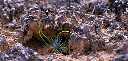
In Arches, the requirements for backcountry camping include being at least a mile from any road and out of view of any arches. After talking to a ranger we decided to hike out from a trail area in the Windows Section called the Cove of Caves. Most of the area was relatively flat and with only low-level vegetation (pretty easy hiking); the challenge was hoping over “lava.” In this case, the lava was a biological soil crust composed mainly of cyanobacteria, an algae-like microbe that binds soil into clumps and performs nitrogen fixation, a process that makes nitrogen in the air available to plants. This is essentially how plants are able to grow in a desert like this. It takes about 50 years for this crust to fully develop, at which point it looks like this:

Let me tell you, this stuff was not easy to avoid. It was a relief when we got to the stream wash (a temporarily dry stream bed) where the crust can’t grow and we could walk without planning every step. Below is an image of our campsite, where we had the first of many incredible star-gazing evenings and a moon so bright I actually thought someone was shining a flashlight on our tent at one point.

Our backcountry camp (right side of photo) in Arches National Park.

The next morning we hiked out and drove to the Grand Canyon, and the morning after that I found myself staring out into the abyss with a full pack and an acrobatic stomach.

Saturday, April 21, 2012

Threshold of the Prelude to the Preface of the Prologue

“We must learn to reawaken and keep ourselves awake, not by mechanical aids, but by an infinite expectation of the dawn, which does not forsake us even in our soundest sleep. I know of no more encouraging fact than the unquestionable ability of man to elevate his life by a conscious endeavour. It is something to be able to paint a particular picture, or to carve a statue, and so to make a few objects beautiful; but it is far more glorious to carve and paint the very atmosphere and medium through which we look, which morally we can do. To affect the quality of the day, that is the highest of arts.”
-Thoreau

That’s what this is all about, I’m awake now and the dawn is rapidly approaching. Since I first got my backpack at the sporting goods store I worked at, crazy hike has followed crazy hike. Twenty plus milers? No problem! South rim of the Grand Canyon to the Colorado River and back in a day? Well why the heck not?  Two thousand miles from Maine to Georgia? Uh…duh!


I like to push myself, sometimes too far. This is where Jess comes in. I couldn’t do the Appalachian Trail without her. Not only has she done most of the planning, created this awesome website and bought all her gear from scratch: she’s my balance. Jess is the sanity to my insanity. We are the ultimate team, and the Appalachian Trail? Just our first victim.

So here we are just about two months from the beginning of our hike. It doesn’t seem real yet. We’ve got all the gear, probably too much just like everyone else. We bought or plane tickets to Maine. We’ve got a way back when we get to Georgia (thanks Alan and Amy!!!).  We’ve resigned from our jobs.

My current feelings are best illustrated by two things: 1) The part of Indiana Jones and the Last Crusade when Indiana Jones takes the leap of faith and just so happens to find the camouflaged bridge.

                                 I’m glad you’re joining us for this grand adventure! Happy Reading!